

Geologists have created the first geological map of a lost continent that was found near New Zealand in 2017. The name given to it is Zealandia, or Te Riu-a-Māui in the Māori language and it’s a massive area, nearly twice the size of India’s subcontinent, covering over five million square kilometers.
What’s surprising is that most of it, about 95 percent, is underwater in the southwest Pacific Ocean. Only a few parts protrude out of the water, such as the two islands of New Zealand and some additional small islands, as reported by Forbes.
Some have wondered if this hidden continent could be linked to the legendary lost city of Atlantis. However, that wouldn’t be possible because Zealandia sank under the ocean long before humans existed on Earth.
Geologists define a continent based on specific geological characteristics, including a thick continental crust primarily composed of granite or similar igneous rocks. Classification also depends on the presence of metamorphic rocks formed in tectonically active regions and sediments deposited through erosion on the land surface.
Zealandia indeed meets these geological criteria, but because it’s mostly submerged and challenging to access, our knowledge of its detailed geology is limited, according to Forbes.
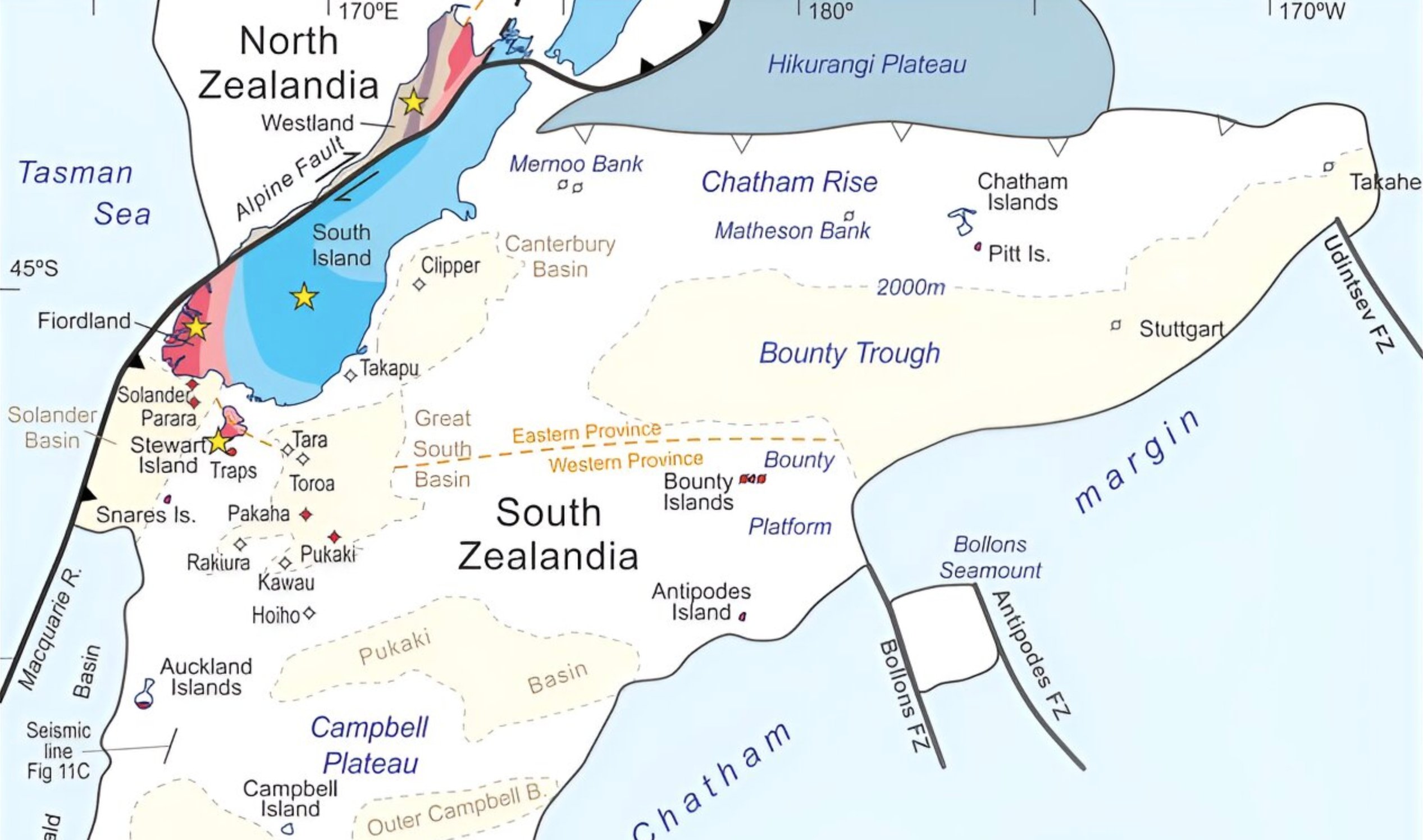
New geological map of lost continent, Zealandia, using rock samples
A team of geologists from New Zealand, New Caledonia, Australia, the United States, Denmark, and Tasmania have collaborated to create a new geological map of Zealandia.
They utilized a combination of techniques, including collections of rock samples from the seabed and the employment of geophysical mapping methods.
Did you know there was an eighth continent?
It's called Zealandia – or Te Riu-a-Māui in the Māori language – with roughly 95% of it lying below the ocean. The most recognisable land mass on the continent is the country of New Zealand.
Zealandia was finally discovered in 2017,… pic.twitter.com/TCnHHd48gl
— Ben (@BenNderituM) September 26, 2023
The researchers collected rock samples from a variety of sources, including the shores of different islands, drilling operations in the open sea, and dredging from the seafloor north of New Zealand.
These samples were crucial in mapping geological formations beneath the water’s surface. Among their findings were extensive sandstone formations that traced the outer boundaries of Zealandia and deposits of basaltic rock pebbles, as reported by Forbes.
Sandstones discovered are 95 million years old
The sandstones found in Zealandia are estimated to be around 95 million years old. They contain older pebbles composed of granite and volcanic rock. There is the implication that when Zealandia was above water, rivers flowing from volcanic highlands filled up tectonic basins in the region.
These highlands were once an active volcanic range, dating back at least 30 to 50 million years earlier, but they were likely significantly eroded by the time the sandstone was deposited.
An analogous landscape to this depositional environment can be found in the Basin and Range province, which covers a substantial part of the Western United States and northwestern Mexico today.
See all the latest news from Greece and the world at Greekreporter.com. Contact our newsroom to report an update or send your story, photos and videos. Follow GR on Google News and subscribe here to our daily email!
