

Declassified images taken by US spy satellites during the Cold War have revealed hundreds of previously unknown Roman-era forts in the Middle East, particularly in what is now Iraq and Syria, resulting in a plethora of new archaeological discoveries.
Some of the pictures they took are helping archaeologists discover new things in parts of the world that are hard to get to.
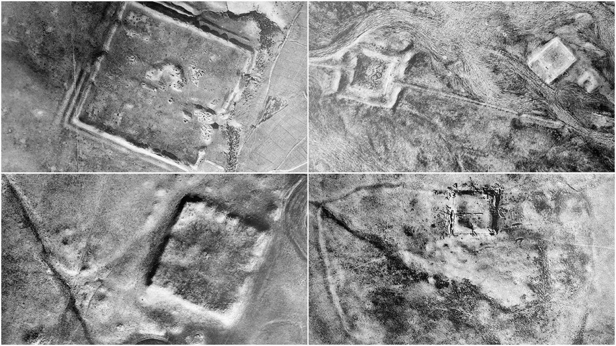
Recent discovery of forts
The recent discovery of 396 forts visible from space confirms and expands upon an aerial survey conducted in 1934. Back then, the survey found 116 forts along the eastern border of the Roman Empire. Archaeologists still agree with the main idea of that study, which is that Rome was fortifying its border.
Jesse Casana, a professor of anthropology at Dartmouth College, explained that “these forts are similar in form to many Roman forts from elsewhere in Europe and North Africa. There are many more forts in our study than elsewhere, but this may be because they are better preserved and easier to recognize.”
He further said, “However, it could also have been a real product of intensive fort construction, especially during the second and third centuries AD.”
History of the Roman Empire
Most historians believe that the Roman Empire started around 27 BCE. Before that, the Roman Republic was going through a long civil war. Some senators killed Julius Caesar in 44 BCE because they thought he had become too powerful.
After that, the Senate supported Octavian, who was Caesar’s heir. They gave him temporary powers to lead an army. In simple terms, Octavian beat his rivals.
In 27 BCE, the Senate gave him permanent leadership powers, and he became known as Augustus, meaning “the exalted one.” He said he wanted to “restore the Republic,” but he also wanted to gather power for himself and his successors.
The line of rulers called “emperors,” continued after Augustus for many years. But during the time when the newly discovered Roman forts were built – roughly from the second to the sixth centuries CE, with some other times included – there were problems.
Especially in the third and fourth centuries, there was no clear plan for who would be the next emperor. This led to a lot of assassinations and takeovers.
Disintegration of the Roman Empire
The vast Roman Empire, which stretched from Britain to Egypt, had a tough time keeping its borders secure. This was partly because it was so huge and partly because nomadic groups, dealing with changes in the climate, kept causing problems.
After some changes, the Roman Empire was officially split in two in 395 CE, after the Emperor Theodosius I died. Other people gradually took over the western part, while the eastern part continued as what we now call the Byzantine Empire until around the 1400s CE.
Studies related to the forts
In 1934, a French archaeologist named Antoine Poidebard found 116 forts in an aerial survey based on flights done in the 1920s. He thought these forts were meant to defend against the Persians, specifically the Parthians and the Sasanians, who were big powers at the time.
But there’s a limitation to his work – he mainly flew his plane where he thought forts might be. Also, those surveys were done before we had modern archaeological standards.
On the other hand, the new study by Jesse Casana and other researchers, using satellite images, covered more ground and balanced out the bias in Poidebard’s study.
They found 396 forts, and these new forts didn’t seem to have a clear north-south defensive plan against eastern people. Instead, they were spread out in a different way.
Forts too spread out to create a line of defense
The latest findings may support the beliefs of some earlier experts who said the 116 roman empire forts discovered by Poidebard were too spread out to create a solid line of defense.
It’s possible that these encampments in present-day Syria and Iraq were meant to safeguard trade caravans carrying valuable items to and from Rome’s regions. They might have also served as hubs for communication and cultural interactions.
The images used in the study were obtained through two satellite programs that were initially created for spying during the Cold War, a period of intense rivalry between the United States and the Soviet Union, along with their allies.
Both nations were focused on advancing military technologies and space missions for political, economic, and propaganda purposes, with minimal use of actual weapons.
Space race during the Cold War period
During this time, there was a fierce competition known as the “Space Race,” where both superpowers raced to achieve significant milestones in human and robotic space exploration. This included launching the first humans into space and sending spacecraft to explore our solar system.
At times, this rivalry also led to collaborative efforts, like the joint Apollo-Soyuz Test Project mission in 1975, which saw American astronauts and Soviet cosmonauts working together.
One of the key goals of the Cold War was to quickly gather military information using satellites that could capture and transmit detailed images of the Earth’s surface. The Central Intelligence Agency’s Corona program, with support from the U.S.
Air Force, conducted imaging operations in countries such as China and the Soviet Union from 1959 to 1972. A successor program called Hexagon, also known as Big Bird, KH-9, or KeyHole-9, continued to survey Soviet military areas from 1971 to 1986 and was managed by the National Reconnaissance Office.
Declassified spy satellite images reveal 400 Roman Empire forts in the Middle East pic.twitter.com/UP0wtX5QTC
— Nazar Bruineman (@merrick_ivy) October 26, 2023
Declassification of images from the Cold War period
The declassification of these images has opened up a valuable resource for archaeologists, according to Casana, making it easy to access and relatively affordable.
“All the satellite images we used in this study are publicly available through the U.S. Geological Survey, who serve them on their EarthExplorer data distribution portal,” he explained. “Images that are already scanned can be downloaded there for free, while unscanned images can be purchased for $30 USD.”
Apart from continuing the work of Poidebard, who was recognized as an influential figure in the “long history of scholarship” mentioned in the new study, the declassified Corona and Hexagon images offer other valuable advantages to archaeologists.
Threat to ancient sites
It’s important to understand that ancient sites like roman empire forts face numerous threats. While the public and media often focus on damage caused by looting and military activities, archaeologists have found that the destruction of sites due to urban development, increased agriculture, and dam construction is much more widespread and severe.
Climate change also plays a role in these issues, as communities try to safeguard their food and water resources in response to a warming planet.
Casana emphasized that the true worth of historical, high-resolution imagery like Corona and Hexagon lies in preserving a snapshot of a landscape that, for the most part, no longer exists. He pointed out that the spy imagery is about fifty years old, and significant changes have occurred in Iraq and Syria since then.
Additionally, the study helps shed light on the fact that an unknown number of other sites were likely lost between Poidebard’s flights in the 1920s and the Corona imagery from the late 1960s.
See all the latest news from Greece and the world at Greekreporter.com. Contact our newsroom to report an update or send your story, photos and videos. Follow GR on Google News and subscribe here to our daily email!
