

Kokkinopilos, Greece, consists of a stretch of red land and sand dunes that resemble the planet Mars, making it a unique geological phenomenon in the country.
It is located in the region of Preveza, northwestern Greece, between the two small villages of Rizovouni and Agios Georgios.
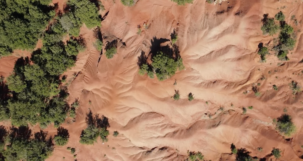
Kokkinopilos is a primal stretch of hills consisting of red earth topped by lush vegetation. The color of the ground is more intense during sunrise and sunset of course, creating a magical landscape of colors.
The red dunes incline five degrees to the northwest, because of a natural fault line which is located in the area. On rainy days, water passes between the gorges and ends in the nearby valley rim, resulting in the red coloring.
Kokkinopilos, Greece has red land like Mars
These magical landscapes can only be found in Mediterranean countries because they are close to Africa, after southern winds brought African sand from the Sahara Desert and the Sahel.
According to researchers, prehistorically the land at Kokkinopilos was much flatter. The characteristic dunes found there used to contain ponds that have dried out over the millennia.
This stunning red land was explored by Eric S. Higgs in 1962 who also made important Palaeolithic and Bronze Age archaeological discoveries there.
A Roman aqueduct built during the reign of Octavius Augustus runs from the Louros River to Nicopolis through the Kokkinopilos Valley.
The town of Kokkinopilos was founded in the Middle Ages by farmers, and was captured by the Ottomans in 1442.
During the Greek War of Independence, villagers revolted against Ottoman rule, but their plan failed. The town was later looted and captured by Ottoman soldiers. The area was eventually liberated by the Greek Army in 1912.
Geology of Greece
The story of Greece and its geology begins around 250 million years ago when the continents had all come together into one single land mass that geologists call Pangea.
The area that would one day become Greece lay on the southern shore of what would eventually become Europe and on the northern edge of a great ocean called Tethys. On the southern edge of Tethys lay the continent that would one day become Africa.
The Earth’s crust is not all the same, nor is it a single unit. The crust making up the continents is very thick; 30 km to 40 km (18.6 to 24.85 miles) thick — and it is thicker still under mountain ranges. The crust under the oceans is quite thin, however, only around 7 km (4.3 miles) thick.
In addition, the crust is not one single unit but is broken up into various sized chunks known as tectonic plates. These plates move relative to one another because they are literally floating on the deformable layer of the upper mantle beneath them, in much the same way that a ship floats on the sea.
In some places these plates are moving together and where oceanic crust is pushed into continental crust the thinner oceanic crust is forced beneath the thicker continental crust and down into the mantle, where it begins to sink and melt. Geologists call this type of plate boundary a subduction zone.
The Greek landscape and geology that we see today is here because of a subduction zone. Without it, Greece would simply not exist.
See all the latest news from Greece and the world at Greekreporter.com. Contact our newsroom to report an update or send your story, photos and videos. Follow GR on Google News and subscribe here to our daily email!
