



The Ancient Greek mapmakers were among the earliest thinkers to conceive of the world as a coherent whole, turning centuries of myth, seafaring knowledge, and emerging science into actual pictures—maps that transformed how people understood space and distance.
Their understanding progressed from mythical visions of a ring-shaped ocean to the science and mathematics of a spherical Earth, and, in the process, they laid the groundwork for geography as a discipline and for the modern habit of seeing the globe from an elevated, global perspective.
Ancient Greek mapmakers
Early Greek thinking about the world began with images found in Homer and Hesiod, who described a flat disk of land encircled by ocean. This view, which resembles the views of modern-day flat-earthers, reflected the horizon-limited perspective of sailors and islanders in the Aegean and Ionian Seas.
That easy-to-understand mental picture, though utterly inaccurate, gave later thinkers a template for drawing the oikoumene—the inhabited world—as a bounded shape that could be sketched and debated.
In the sixth century BC, Anaximander of Miletus was credited with producing one of the first world maps, a simple circular plan that divided the world into Europe, Asia, and Libya and placed seas and rivers as organizing lines rather than the borders of the unknown. Although primitive, it was a major step toward a more structured and scientific depiction of the world.
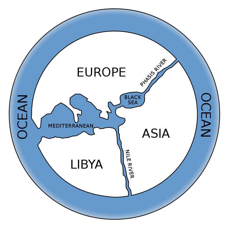
Hecataeus of Miletus was another Ancient Greek figure whose work refined that effort with a companion text. This is often rendered as Journey Around the World (Περίοδος Γης – Periodos Ges) and includes the map to travel by land and sea. It was a crucial shift from myth to method because it tied cartographic outlines to real-life experiences although measurements remained imprecise and the Earth was still conceived as a disk floating in space.
A lesser-known detail from this early phase is that these maps often encoded pragmatic data such as days required for sailing or marching, a true metric that guided merchants and envoys long before standard units were adopted. It was a distant ancient precursor to what we would later come to call a GPS assistant.
From myth to mathematics
By the Classical and Hellenistic periods, Greek scholars increasingly argued for a spherical Earth, a view associated with thinkers like Pythagoras and Aristotle, which transformed mapmaking from schematic diagrams into projections of a curved surface.
Eratosthenes of Cyrene, working in Alexandria in the third century BC, famously estimated the Earth’s circumference using the angles of shadows at Syene and Alexandria at noon on the solstice. He then overlaid the known world with a grid of meridians and parallels and introduced the very term “geography,” envisaging climate zones and turning the map from a traveler’s aid into a scientific tool that could be updated based on the latest reports.
Another pivotal Ancient Greek figure whose work greatly influenced modern-day maps was Marinus of Tyre. Marinus systematized the use of latitude and longitude and chose a prime meridian through the westernmost known isles at the time, anticipating later conventions. His work enabled Claudius Ptolemy in the second century AD to compile Geographia, a monumental synthesis that listed thousands of place coordinates and explained the projection of a sphere onto a plane. Ptolemy’s errors, including the underestimation of Earth’s circumference and overextension of Eurasia, were influential despite being inaccurate, dominating for centuries and seeding both Islamic and European cartographic traditions.
It is safe to argue that Greek cartography placed equal importance on lived experience and cultural knowledge. Strabo, the famous Greek geographer of the first century BC, working during the transition from the Roman Republic to Empire, wrote the monumental Geographica, a 17-book encyclopedia that presented a fully descriptive history of people and places across the known world.
Unlike the coordinate-based approach of Ptolemy, Strabo’s work combined personal observations from his extensive travels, including trips he made up the Nile to Philae and throughout the Mediterranean. By also making use of excerpts by earlier authors, he created what might be called an early ethnographic atlas.
His Geography preserved spatial information and cultural details on just about everything from elephant training and saffron collecting to religious festivals and regional customs. Strabo explicitly argued for Greek intellectual primacy while acknowledging Roman political dominance, and his work served as a bridge between the abstract mathematical geography of the Hellenistic period and the practical needs of Roman administrators and merchants.

How Ancient Greek cartographers imagined the world, leading to our modern-day maps
Greek mapmakers imagined the world as a knowable system with centers, boundaries, and climate zones, not simply a scatter of ports and mythical stories. This precise system-thinking is still the foundation of modern mapping. The habit of placing the Mediterranean at the center of these maps reflected trade routes and cultural focus, as the broader Mediterranean area was indeed the center of the ancient world from a distinctly Eurocentric perspective. One may claim that this was an early lesson in map bias still applicable in debating which projection or prime meridian to utilize today.
Their climate zones, drawn as belts across the globe, were a precursor to contemporary ways of visualizing environmental regions and continue to shape geographers’ categorization of large-scale areas today.
A revealing example of how the past meets the present lies in Ptolemy’s coordinate lists, which allowed later cartographers to reconstruct maps even when originals were lost, much as modern GIS can regenerate layers from databases. Likewise, the practical metrics of early Ionian maps, expressed as travel time rather than fixed distance, remind us of today’s isochrone maps that show how far rail or bus networks can take a person within an hour.
What began as an imaginative leap to see the world from above has become an everyday interface, yet the Greek insistence that maps can be argued, measured, and revised remains a defining feature of modern cartography.
Ancient Greek mapmakers and modern identity
Modern debates about borders, centers, and peripheries are still shaped by those early Greek maps, which taught viewers to read space as ordered and comparable. When a map puts north at the top or draws lines of latitude and longitude, it follows conventions that were refined by Hellenistic scholars, and when global institutions rely on gridded data, they are drawing on the legacy of Eratosthenes and Ptolemy more than they might admit.
Even disputes over what constitutes Europe or where Asia begins have roots in those Ancient Greek mapmakers who first carved the world into regions with names and boundaries and then passed those categories into law, culture, and education.
The Greeks also modeled a critical stance toward inherited images, abandoning the ocean-ring when evidence demanded it and revising coastlines as sailors returned with logs and soundings. That habit of updating the map as new information was gleaned remains essential in an age of satellite imagery and crowdsourced data.
See all the latest news from Greece and the world at Greekreporter.com. Contact our newsroom to report an update or send your story, photos and videos. Follow GR on Google News and subscribe here to our daily email!

